![]()
|
|
Prehistoric Sites in
WALES
by Martin J. Powell
Page 4 of 5
Click on a thumbnail to see a full-size picture. The Ordnance Survey Map links (O.S. Map) point to the 1:25,000 scale map of the region (equivalent to the O. S. Pathfinder Series of printed maps), as displayed at Streetmap.co.uk.
The abbreviation 'Ast' indicates that the site is included in the archaeoastronomy study of monuments in South Wales.
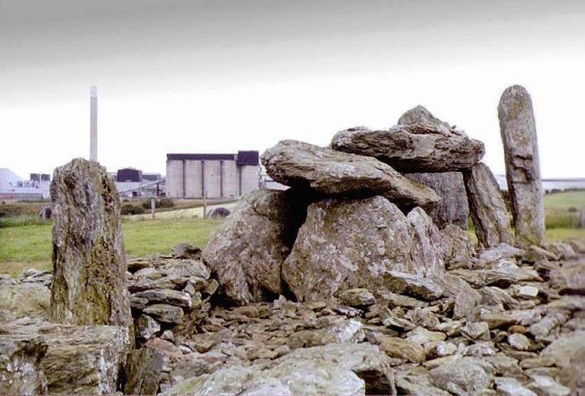
Trefignath Chambered Cairn County: Anglesey (Ynys M�n) Ordnance Survey Grid Ref: SH 259 805 O.S. Map (Streetmap) Satellite Photo (Google Maps) Photo Size: 82 KB / Date: July 1987
The site was excavated from 1977-9, which showed the cairn to be a multi-period construction. Around 3100 BC a simple rectangular chamber was built at the Western end, set in a small round cairn. A larger chamber with 9 ft (2.7 m) high portals was then constructed to the East of the first chamber together with a long, wedge-shaped cairn and a forecourt. A third chamber was then built within the forecourt, together with its own forecourt, and the cairn was extended Eastward. Pottery was found during the excavation, but no burials. The site was probably in use for five or six centuries. |
Carreg Bica a.k.a. Maen Bredwan Standing Stone County: West Glamorgan O.S. Grid Ref: SS 725 995 O.S. Map (Streetmap) Photo Size: 65 KB / Date: January 1987
There are two local legends attributed to the stone. One says that whenever it hears a cock crow, it visits the River Neath (Afon Nedd) for a drink. The other says that the stone bathes in the river every year on Easter morning. There are many legends in Wales which associate standing stones with nearby water courses; folk tales such as these, passed down and embellished through the generations, may in some cases hint at an original function for these enigmatic monuments. |
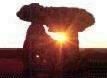
Druid's Circle (Penmaenmawr) Stone Circle County: Gwynedd (Caernarvonshire) O.S. Grid Ref: SH 723 746 O.S. Map (Streetmap) Satellite Photo (Google Maps) Photo Size: 66 KB / Date: July 1987
The site was excavated in 1958. At the centre of the circle was a scattering of stones and a cist with an inverted food-vessel and the cremated remains of a ten-year-old child. The site is thought to date from around 2100 to 1750 BC. The noted archaeoastronomer Prof. Alexander Thom proposed two solar and one stellar alignment visible from within the circle. He suggested the shape of the ring was based on a ellipse with an ESE-WNW axis. However, it is equally likely that the stone circle was elliptical because its builders had made allowance for a prehistoric trackway which touched the monument on its Northern edge. Many prehistoric sites across Wales are often associated with the Druids - the high priesthood of the Iron Age Celts - or are named after them, e.g. Druids Circle, Druid Stone, etc. However, the Druids did not build these monuments; when the Druids were at the height of their influence - in the final centuries before the Roman Conquest of Britain - these megalithic sites had already been in existence for at least a thousand years. A reconstruction painting by Paul Jenkins (ca. 1980) of a burial ceremony taking place at the Druid's Circle can be seen at the National Museum Wales website. |
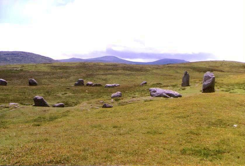
Pedwar Maen a.k.a. Four Stones, Bryn-y-Maen Stone Row County: Powys (Radnorshire) O.S. Grid Ref: SO 156 568 O.S. Map (Streetmap) Photo Size: 358 KB / Date: April 2004
Although the name of the site refers to the presence of four stones ('pedwar maen'), there appear to be five stones in this row, the fifth being at the South-western end; it is now recumbent and largely submerged in the turf. The five stones form a NE-SW line about 52 ft (16 m) in length. From Northeast to Southwest the heights of the four visible stones are: 1 ft 6 in (0.46 m), 1 ft 6 in (0.46 m), 2 ft (0.61 m) and 2 ft 6 in (0.76 m). The original standing height of the now-submerged stone is not known. Interestingly, the measurable stones are graded in height towards the South-west. When extended towards the North-east the row points to a tumulus (a round barrow or cairn) some 200 ft (60 m) away, which may be associated with it. Modern trackways converge next to the row. |
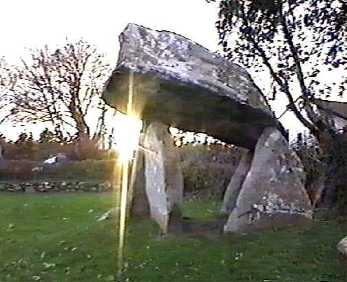
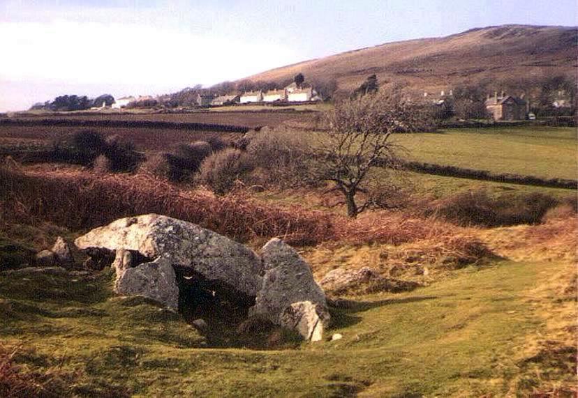
Gwern-y-Cleppa a.k.a. Cleppa Park Burial Chamber County: Newport (Gwent) O.S. Grid Ref: ST 276 851 O.S. Map (Streetmap) Photo Size: 89 KB / Date: March 1987
The remains of the burial chamber are positioned at the Eastern end of a long, low mound approximately 134 ft (41 m) long, orientated East-West. The chamber is composed of siliceous grey sandstone, with four orthostats and a collapsed capstone. It is reasonable to assume that in its original form the monument would have been a simple terminal chamber of the Severn-Cotswold type. |
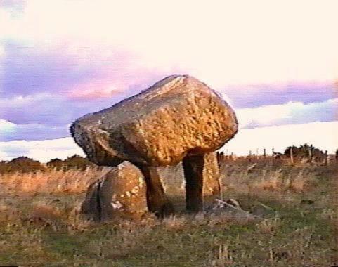
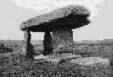
Llech y Dribedd Burial Chamber County: Pembrokeshire (Dyfed) O.S. Grid Ref: SN 100 432 O.S. Map (Streetmap) Video frame Size: 31 KB / Date: November 1999
Three orthostats standing 4 ft (1.2 m) tall support a wedge-shaped capstone 10 ft (3 m) long, 6� ft (2 m) wide and ca.4 ft (1.2 m) thick. A fourth stone lies prostrate nearby, which may originally have been a fourth upright, according to a 1693 account of the site. The chamber is orientated just to the South of East. Archaeologist Frances Lynch considers the site peculiar in its class, due in part to the "odd angle at which the portal stones are set, neither well-aligned to the chamber nor parallel to one another." A local legend says that St Samson hurled the stones to this spot from the summit of Carn Ingli. |
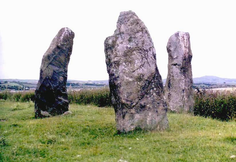
Meini Hirion (Llanfechell) Standing Stones County: Anglesey (Ynys M�n) O.S. Grid Ref: SH 364 917 O.S. Map (Streetmap) Photo Size: 77 KB / Date: July 1987
The wide spacing and placement of these stones make it unlikely that they are the remnants of a burial chamber. British archaeologist Aubrey Burl has suggested that these and similar settings of stones may have been coves - Bronze Age representations of the Neolithic burial chambers which preceded them. Some 0.4 miles (0.6 km) East of the Meini Hirion is a 6.5 ft (2 m) high standing stone known as Llanfechell East (SH 369 916). The stone fell in 2009 and its socket was excavated in the following year. The stone weighed 4.6 tons and its total length was 8 ft 2 in (2.5 m); about 1� ft (0.5 m) of this was below ground level. At least 20 packing stones were found in the socket, one of which was found to have a cup-and-ring marking and a single cupmark carved upon it. Beneath the packing stones was a pit containing dark humic soil and charcoal, which were most likely ritual offerings deposited before the stone was raised. The standing stone was re-erected in its original position in September 2010. About 0.3 miles (0.5 km) to the North-west of the Meini Hirion is a collapsed Neolithic burial chamber at Cromlech Farm (SH 360 919). The monument contains numerous cupmarks, one on a large stone on its Eastern side (which was possibly the original capstone) and a further four on the southern part of the site. More cupmarks were discovered on two rock outcrops - positioned between the burial chamber and the Meini Hirion - during archaeological fieldwork undertaken in 2005-6. |
Ty Newydd Burial Chamber County: Anglesey (Ynys M�n) O.S. Grid Ref: SH 344 738 O.S. Map (Streetmap) Photo Size: 123 KB / Date: July 1987
Excavation in 1935 revealed a layer of black earth within the chamber, which contained a considerable amount of charcoal. An arrowhead, pottery fragments and pieces of white quartz were also found, but there were no signs of burial. Evidence from the excavation suggested that the chamber, although built in the Neolithic period, was also used during the Bronze Age. A fallen stone was re-erected during the excavation. Early accounts of the site refer to other stones in the vicinity which were possibly the remnants of a second chamber, or a passage. As is the case at many prehistoric sites in Britain, the name of this monument does not describe the monument itself, but is a name taken from that of a nearby farmhouse or other residence. |
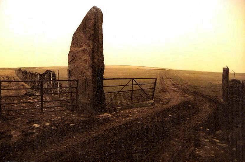
Carreg Hir Standing Stone County: Powys (Montgomeryshire) O.S. Grid Ref: SO 014 969 O.S. Map (Streetmap) Photo Size: 86 KB / Date: November 1995
The stone is orientated ENE-WSW. Interestingly, this is approximately the direction to a recently-discovered stone circle called Llyn-y-Tarw (SO 025 972) which is about 0.75 miles (1.2 km) to the ENE of the stone. The circle is 62 ft (19 m) in diameter and has at least 39 stones. The circle was not discovered until 1981 because the stones were very small and were deeply buried in the peat. |
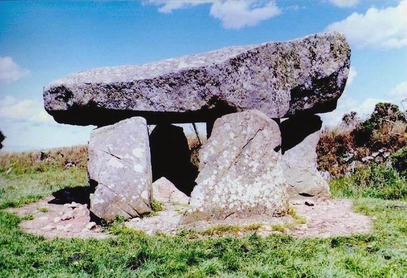
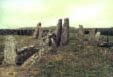
Carreg Coetan Arthur a.k.a. Coetan Arthur, Pen y Bont Burial Chamber County: Pembrokeshire (Dyfed) O.S. Grid Ref: SN 060 393 O.S. Map (Streetmap) Video frame Size: 45 KB / Date: November 1999
The capstone is 10� ft (3.2 m) long by 9 ft (2.7 m) wide and rests on just two orthostats. A portal stone at the Eastern corner is missing, and would be expected to have existed, however excavation of the site in 1979-80 did not reveal any indication of a stone socket in this position. Also found during the excavation were cremated human bone and carinated bowl sherds of Neolithic date. Four areas of cremation deposits were identified at the site, both outside and inside the chamber. One cremation deposit, situated on the original ground surface beneath an inverted pot, was radiocarbon-dated to ca. 3620-3020 BC. An arc of small stones, similar to a ring cairn, was found curving around the chamber's Southern side. The excavation demonstrated that cremation was practised at such tombs as early as the fourth millenium BC, as opposed to inhumation which was typically found at many tombs of this period. The excavator speculated that cremation deposits such as these were likely to have been 'token deposits', added at a later stage to an already-revered 'ancestral tomb'. As at Llech y Dribedd (see above), the apparent height of the portal was intentionally exaggerated by the use of a wedge-shaped capstone. |
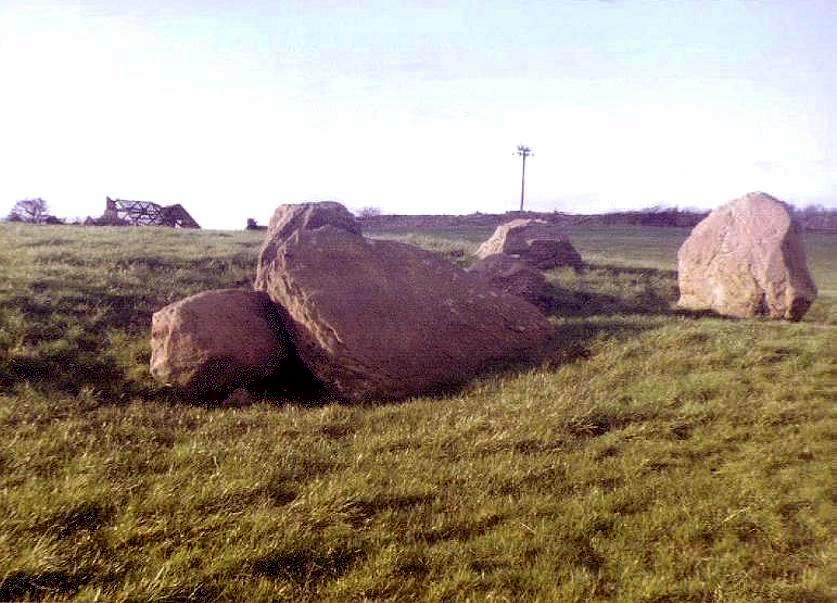
Pen-maen Burrows Burial Chamber County: West Glamorgan O.S. Grid Ref: SS 531 881 O.S. Map (Streetmap) Photo Size: 99 KB / Date: February 1988
The main chamber is 13 ft (4 m) long by 6� ft (2 m) wide, made of six uprights. The Southern chamber opens from the main chamber and measures 8� ft (2.6 m) by 4� ft (1.4 m). The capstone has been displaced from its original position. There was probably a third chamber on the Northern side and possibly a covering cairn, but they are obscured by a sand dune. There were minor excavations in 1860 and 1881. A human jaw fragment, animal bones, a piece of a bone tool handle and pieces of pottery were recovered from the Southern chamber [Ast] |
 Archaeoastronomy
in South Wales
Archaeoastronomy
in South Wales
 Neolithic
Tombs in South Wales
Neolithic
Tombs in South Wales
Copyright Martin J Powell 2001 - 2015