![]()
|
|
Prehistoric Sites in
WALES
by Martin J. Powell
Page 3 of 5
Click on a thumbnail to see a full-size picture. The Ordnance Survey Map links (O.S. Map) point to the 1:25,000 scale map of the region (equivalent to the O. S. Pathfinder Series of printed maps), as displayed at Streetmap.co.uk.
The abbreviation 'Ast' indicates that the site is included in the archaeoastronomy study of monuments in South Wales.
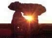
Parc Cwm a.k.a. Parc-le-Breos Cwm, Giant's Grave Chambered Long Cairn County: West Glamorgan Ordnance Survey Grid Ref: SS 537 898 O.S. Map (Streetmap) Satellite Photo (Google Maps) Photo Size: 108 KB / Date: May 1991
The limestone cairn has been restored and measures 72 ft (22 m) long by 39 ft (12 m) at its widest, Southern end. The forecourt (136 KB) is bell-shaped and displays an impressive dry-stone walling along the two 'horns'. The tomb is entered over a sill-stone into a passage 20 ft (6.2 m) long with two pairs of chambers on either side. The remains of around forty people were found in the 1869 excavation, together with some sherds of Neolithic pottery. The chambers are now all roofless, if indeed they were ever roofed. In 2014 John Cooper successfully demonstrated that a 'roofbox' type structure positioned above and just behind the portal stones would have allowed the rays of the midwinter noon Sun to penetrate the monument and illuminate the rear stone of the passage. There is, however, no surviving evidence to show that such a roofbox ever existed at the site [Ast] Using skeletal fragments recovered from the first excavation, the long cairn was recently radiocarbon-dated to the later part of the Early Neolithic period in Britain (ca. 3500 BC). Detailed study of four long bones from the excavation enabled archaeologists to estimate the stature of the people interred in the chambers. The conclusion was that the females were 'short and gracile' and the males were 'tall and robust'. Indeed, the 1869 excavation concluded that the recovered bones indicated males of 'gigantic proportions'! Isotopic analysis of the bones suggested that the chamber occupants were primarily meat-eaters, plants and grains being consumed on a much lesser scale. Although the tomb is situated near the coast, fish did not form any significant part of their diet. Archaeologists have speculated that this may reflect an association with an earlier Mesolithic way of life, i.e. the hunting of wild animals and/or animal husbandry. Alternatively, the coastal region was perhaps controlled by a different community, whose communal tomb was Penmaen Burrows (see Page 4) some 1.2 miles (1.9 kms) away to the SSW. |
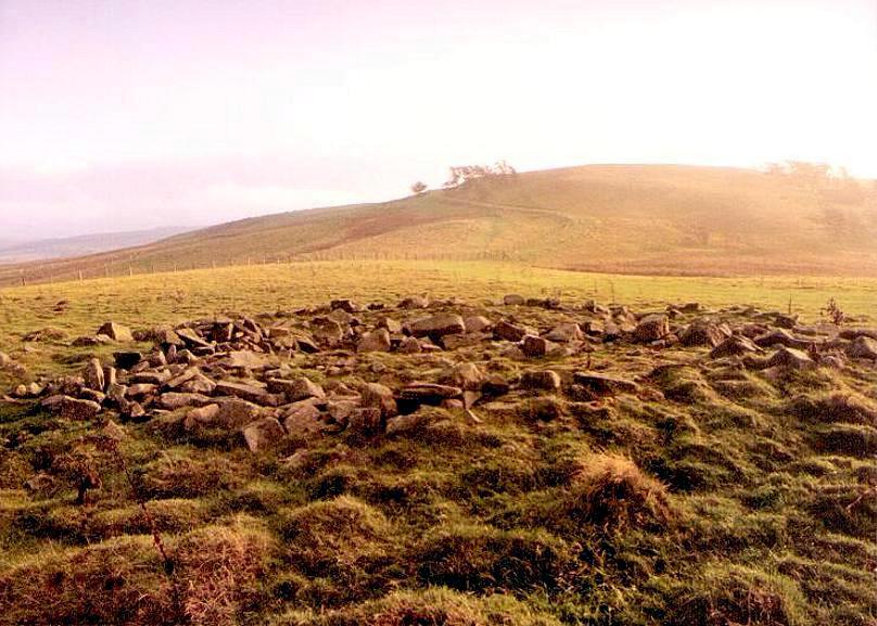
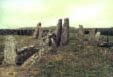
Carn Llechart Cairn-Circle County: West Glamorgan O.S. Grid Ref: SN 698 063 O.S. Map (Streetmap) Photo Size: 85 KB / Date: January 1991
The cairn appears vividly against the skyline when it is approached along the trackway from the North - a factor which probably helped the cairn-builders to determine the location of its construction [Ast] About 230 ft (70 m) to the West of Carn Llechart is what appears to be a ruinous Neolithic chambered tomb (SN 696 063) with a rectangular-shaped capstone measuring 17 ft (5.3 m) long by 8 ft (2.4 m) wide. Some archaeologists consider it to be simply a natural rock outcrop, however the layout and orientation of this 'tomb' is somewhat similar to that of other Neolithic tombs in the Severn-Cotswold region. |
Pentre Ifan Burial Chamber County: Pembrokeshire (Dyfed) O.S. Grid Ref: SN 099 370 O.S. Map (Streetmap) Video frame Size: 22 KB / Date: November 1999
Excavation in 1936-7 found only a few flint flakes and sherds of bowl, but there were no traces of burials. In the early 1970s, archaeologist Frances Lynch identified prehistoric rock art on the outer face of the blocking stone, in the form of a single cupmark and a surrounding ring. The landscape around the tomb is one of the most dramatic of any Welsh tomb, with views of Carn Ingli and other rock outcrops to the West and Newport Bay to the North-west. A recent theory is that the rock outcrops provided a specific focal point when determining the location of the tomb within a 'ritual landscape'. |
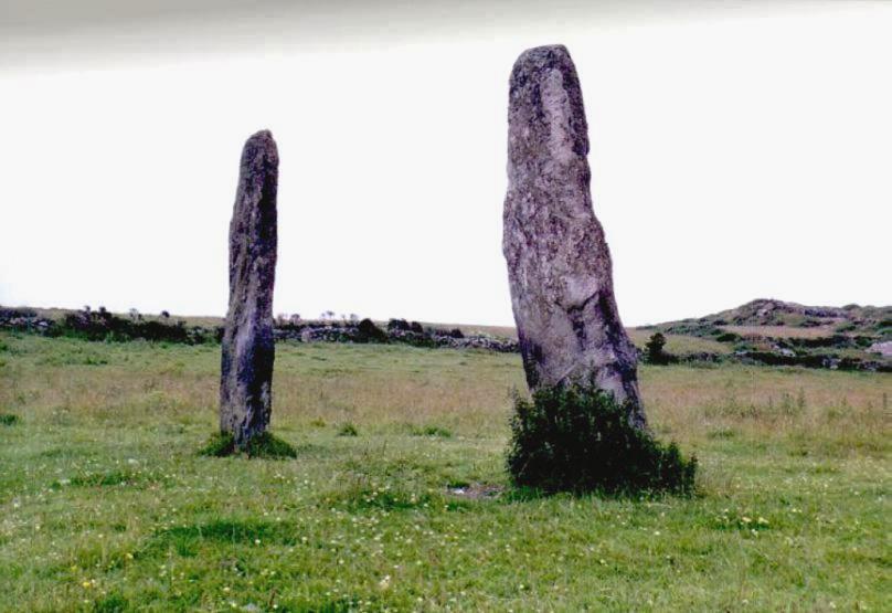
Penrhos-Feilw a.k.a. Plas Meilw Standing Stones County: Anglesey (Ynys M�n) O.S. Grid Ref: SH 227 809 O.S. Map (Streetmap) Photo Size: 60 KB / Date: July 1987
There is a tradition that a cist burial was found between the stones, together with a spearhead and arrowheads, but there is no archaeological evidence to support this. |
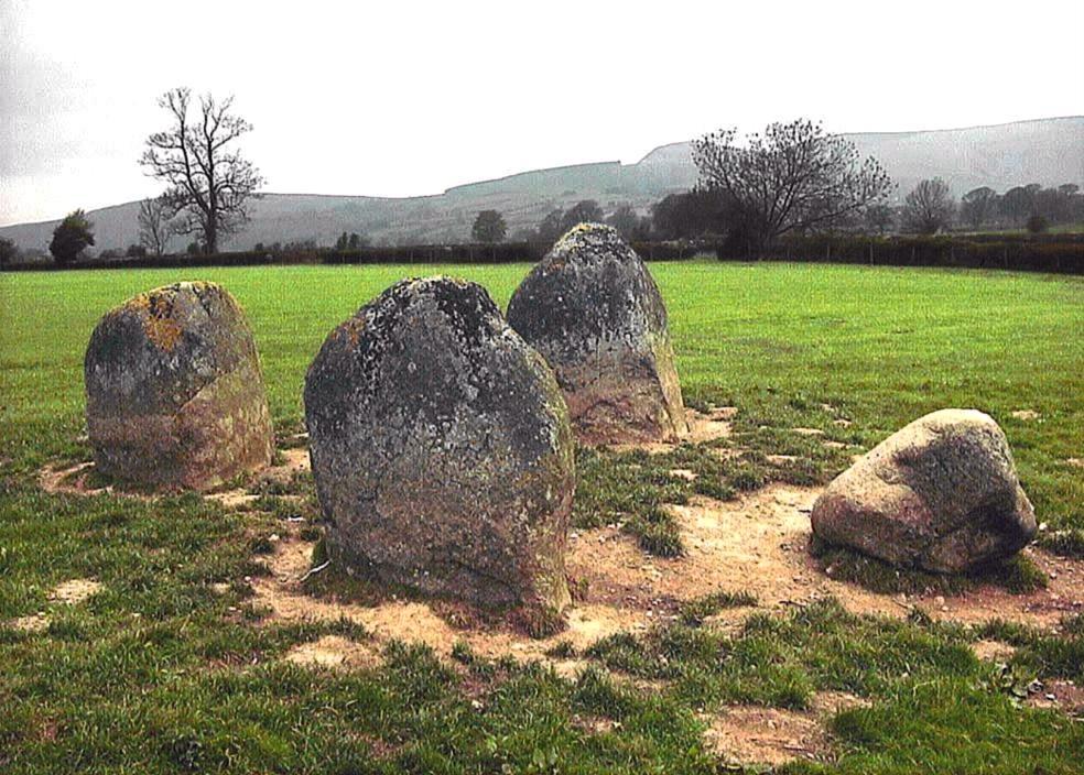
Four Stones Stone Setting County: Powys (Radnorshire) O.S. Grid Ref: SO 246 608 O.S. Map (Streetmap) Site Plan (21 KB) Photo Size: 152 KB / Date: April 2004
The tallest stone at the North-west may have served to indicate the sun as it set behind the dome-shaped Whimble hill (visible in the distance, at centre-right of picture) on the Celtic festival days of Beltane and Lughnasa (present day May Day and Lammas). Like other standing stones in the region (see for example the Kinnerton stone on Page 5), the shapes of these stones appear to mimic the shapes of nearby hills. The stone at the South-west (left of picture) has three cupmarks on its upper surface, and it may have served to indicate the midwinter setting sun. A local legend tells of the stones going to the nearby Hindwell Pool for a drink whenever they hear the bells of Old Radnor church ringing. The reference to the church is interesting, since a local tale says that the early medieval font at St Stephen's Church, Old Radnor - some 1.1 miles (1.7 kms) to the South - was carved from a stone which had been removed from the circle (see photo at Alamy stock photos). Indeed, wide gaps at the North, West and South of the circle (see site plan) could conceivably have accommodated additional stones. |
Banc Carn Round Cairn County: Powys (Radnorshire) O.S. Grid Ref: SO 041 791 O.S. Map (Streetmap) Photo Size: 96 KB / Date: November 1995
A short distance to the North-east of the cairn is the ruinous Banc Du stone circle, also known as Fowler's Armchair because of a nearby boulder which is shaped like a seat. The circle is 42 ft (12.8 m) in diameter and has five upright stones. One of them, named Fowler's Horse Block, is located at the centre of the circle. |
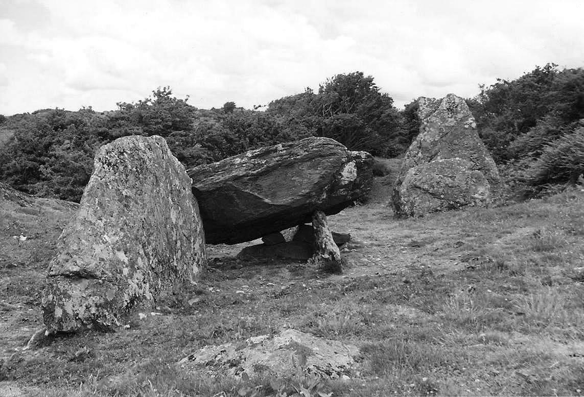
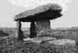
Din Dryfol a.k.a. Din Dryfal, Dinas Dindryfal Chambered Tomb County: Anglesey (Ynys M�n) O.S. Grid Ref: SH 396 725 O.S. Map (Streetmap) Photo Size: 155 KB / Date: July 1987
The tomb comprises chlorite schist rocks which were obtained from the immediate surroundings. The cairn originally measured about 200 ft (60 m) long by 50 ft (15 m) wide. In the excavator's opinion, the surrounding ridges of projecting rock appear to have determined the tomb's size and orientation (NE-SW), the chambers themselves occupying the North-eastern end. The huge portal stone - visible towards the right of the picture - is 8� ft (2.6 m) long, 2� ft (0.7 m) thick and stands about 9� ft (2.9 m) above the present surface level. A second portal once stood some 8 ft (2.5 m) further North; only its base was found during excavation, the upper section having sheared off at some time in the distant past. These two stones marked the entrance to a series of three (possibly four) chambers which stretched along a length of about 41 ft (12.5 m). Only the Westernmost chamber has survived; its internal dimensions were originally about 9 ft 10 in (3 m) by 3 ft 3 in (1 m) and it would have stood about 6� ft (2 m) high; now only a side-supporter is visible (left of picture). The chamber's capstone partly rests on this slab, having slipped forward at some time prior to 1871. Excavation also revealed a pair of post-holes at the entrance to one of the chambers; these may have supported some kind of wooden mortuary structure which existed prior to the chamber's construction. Finds from the excavations included the cremated bone fragments of two adults, pieces of Neolithic pottery, part of a polished stone axe and pieces of waste flint. |
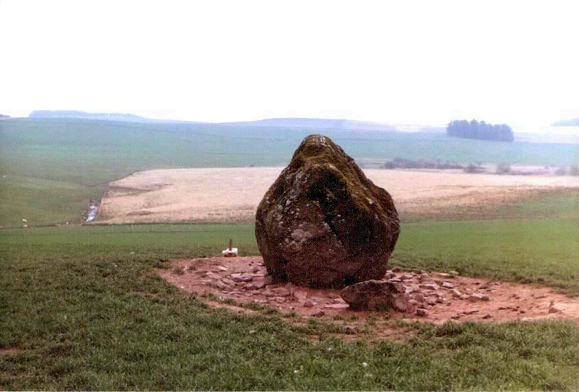
Gwernwyddog Stone a.k.a. Usk Reservoir Stone Standing Stone County: Powys (Brecknockshire) O.S. Grid Ref: SN 833 283 O.S. Map (Streetmap) Photo Size: 70 KB / Date: April 1987
It is one of the most massive standing stones within the Park and is estimated to weigh some 20 tons (20,300 kgs). |
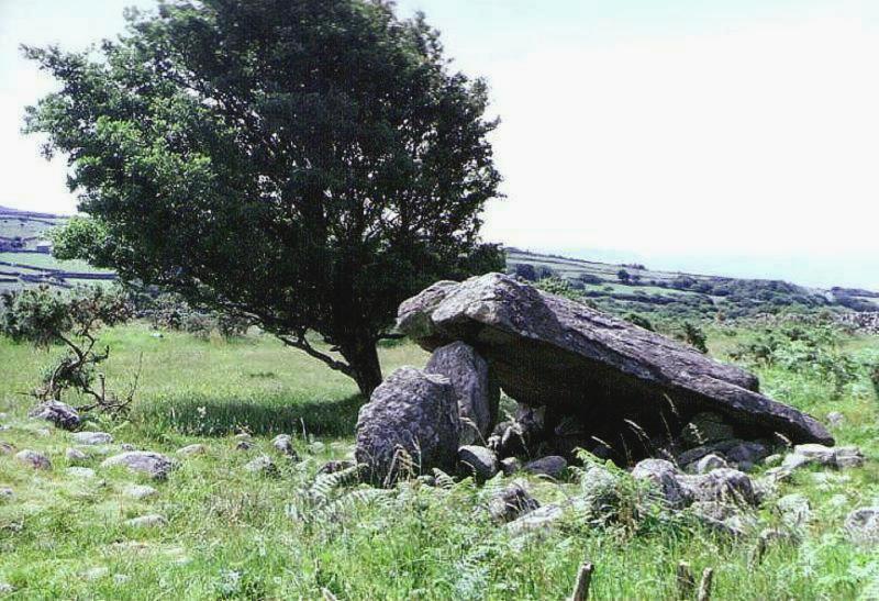
Cors-y-Gedol Burial Chamber County: Gwynedd (Merionethshire) O.S. Grid Ref: SH 603 228 O.S. Map (Streetmap) Photo Size: 105 KB / Date: July 1987
A capstone measuring 11� ft (3.5 m) long by 10 ft (3 m) wide partly rests on a single orthostat. The chamber was probably rectangular in form and it occupies the Eastern end of a denuded long mound about 85 ft (26 m) long by 39 ft (12 m) wide. There are traces of a forecourt structure ahead of the orthostat. |
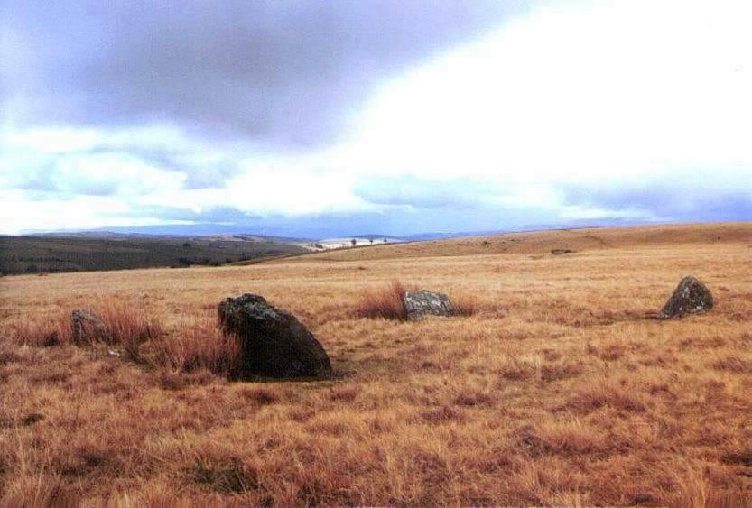
Trecastle Mountain a.k.a. Trecastell Stone Circles County: Powys (Brecknockshire) O.S. Grid Ref: SN 833 311 O.S. Map (Streetmap) Photo Size: 65 KB / Date: March 1987
Professor Alexander Thom proposed three alignments on the sun from within and between the two circles, although he apparently overlooked the stone row because it is so deeply buried in the bracken. The larger circle, 144 ft (44 m) to the North-east, is 75 ft (23 m) across and has 21 small stones which surround a cairn [Ast] A short distance to the West of the circles are the earthwork remains of two Roman temporary marching camps called Y Pigwn (SN 827 312). |
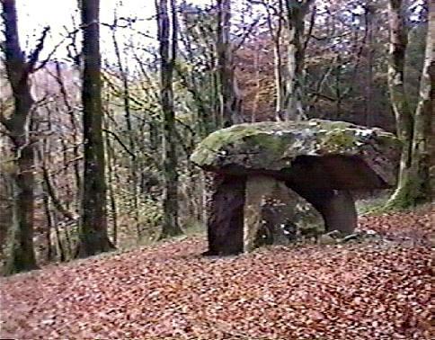
Gw�l-y-Filiast Burial Chamber County: Carmarthenshire (Dyfed) O.S. Grid Ref: SN 170 256 O.S. Map (Streetmap) Video frame Size: 55 KB / Date: November 1999
According to an 1872 account, a gap on the chamber's South-western side was originally occupied by a fifth orthostat. It also referred to a circle of stones around the chamber, although today there are few indications of any covering cairn, or an entrance passage. |
 Archaeoastronomy
in South Wales
Archaeoastronomy
in South Wales
 Neolithic
Tombs in South Wales
Neolithic
Tombs in South Wales
Copyright Martin J Powell 2001 - 2017