![]()
|
|
Prehistoric Sites in
ENGLAND
by Martin J. Powell
Page 4 of 5
Click on a thumbnail to see a full-size picture. The Ordnance Survey Map links (O.S. Map) point to the 1:25,000 scale map of the region (equivalent to the O. S. Pathfinder Series of printed maps), as displayed at Streetmap.co.uk.
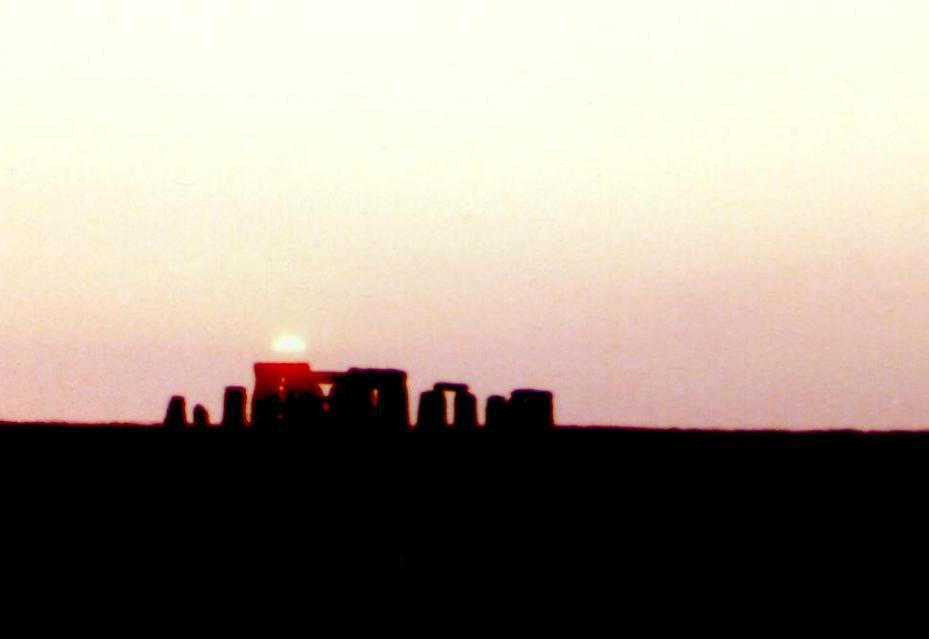
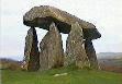
Stonehenge Stone Circle & Henge County: Wiltshire Ordnance Survey Grid Ref: SU 122 422 O.S. Map (Streetmap) Satellite Photo (Google Maps) Photo Size: 22 KB / Date: June 1986
By 2200 BC the focus of attention had turned to the sun. The axis of the henge was shifted to the midsummer sun's rising position at the North-east and an earthen Avenue was constructed. A double-circle of spotted dolerite stones (bluestones) was partly set up, and four Station Stones erected just inside the bank, with alignments to the May Day sunset and the most northerly moonset. Around 2000 BC the Stonehenge that we recognise today was constructed. The bluestones were removed and a ring of thirty sarsen stones erected, topped by lintels, brought from the Marlborough Downs some 20 miles (33 km) to the North of the site. An inner ring of five massive trilithons was erected in a U-shape, standing up to 22 ft (6.7 m) tall and emphasising the alignment along the henge's NE-SW axis. By 1500 BC the bluestone ring had been re-erected in the form of an oval and it was then further re-arranged. The Avenue was extended and re-directed to reach the River Avon to the East. It is commonly assumed that this avenue acted as a processional way when performing ceremonies leading to or from the stone circle. |
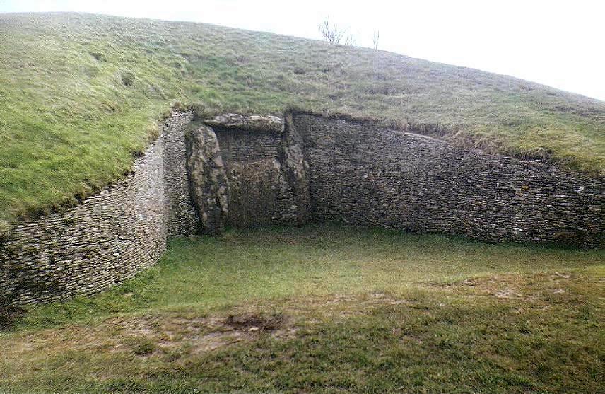
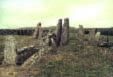
Belas Knap a.k.a. Belas Knapp Chambered Long Barrow County: Gloucestershire O.S. Grid Ref: SP 021 254 O.S. Map (Streetmap) Photo Size: 126 KB / Date: March 1988
The photo shows the false portal at the barrow's Northern end, and the forecourt area in which funerary rituals most likely took place. The barrow is 170 ft (52 m) long, 59 ft (18 m) maximum width and 12 ft (3.7 m) high. There are four polygonal-shaped chambers within the mound, three of them opening from the sides of the barrow (i.e. a laterally-chambered tomb) and the fourth one opening from the narrow tail end. The barrow was restored after excavation in 1928; the lintel of the portal and the upper layers of revetment walling seen in the picture are recent additions. The excavation revealed the skull of a man and bones of five children behind the false portal. The remains of around 30 people were recovered from the remaining chambers, together with a few pieces of Neolithic pottery and flint. The barrow's name derives from the Old English words 'bel-cnaepp' meaning "beacon mound". |
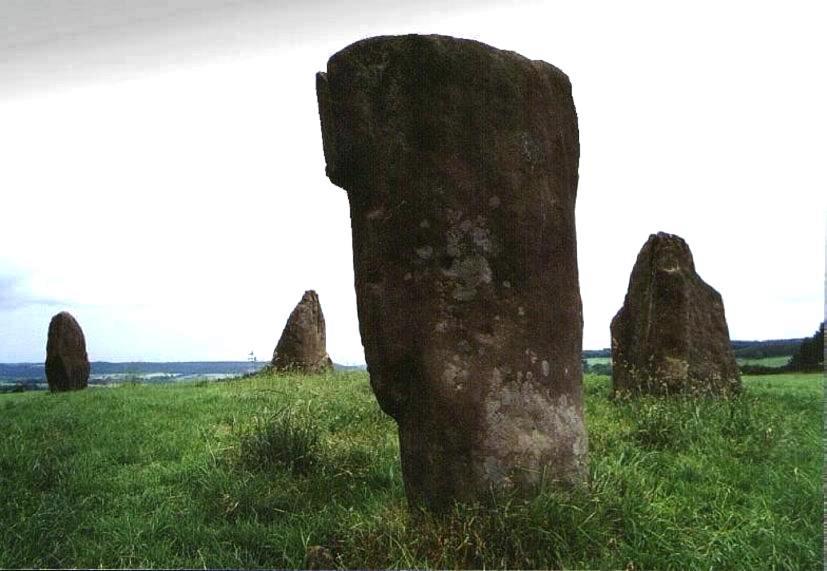
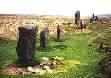
Mayburgh Henge Circle-Henge County: Cumbria O.S. Grid Ref: NY 519 285 O.S. Map (Streetmap) Satellite Photo (Google Maps) Photo Size: 95 KB / Date: July 1989
The entrance faces towards another henge monument a short distance away, known as King Arthur's Round Table (NY 523 283). It measures 295 ft (90 m) across and may once have contained a stone circle on the berm outside its bank. The sites are thought to date from between 2500 and 1700 BC. |
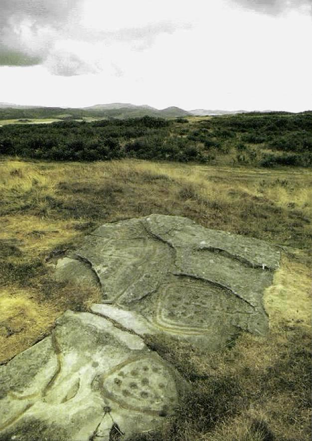
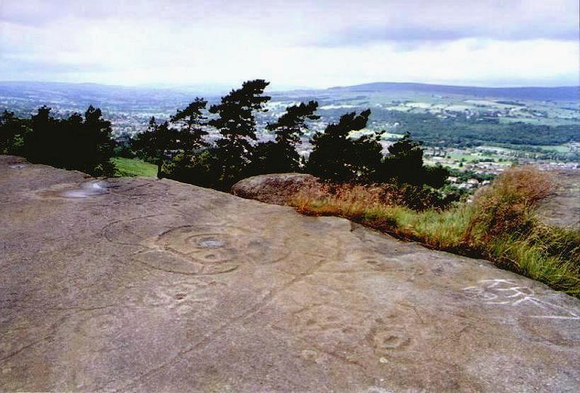
Dod Law Rock Carvings County: Northumberland O.S. Grid Ref: NU 005 317 O.S. Map (Streetmap) Photo Size: 94 KB / Date: July 1989
The Dod Law site is occupied by a golf course, and is one of four important areas of rock carvings in a 11 mile-long (18 km) line running NW-SE taking in Roughtin Linn (see Page 2), Old Bewick (Page 1) and Weetwood Moor (Page 1). |
Nine Stones Close Stone Circle County: Derbyshire O.S. Grid Ref: SK 225 626 O.S. Map (Streetmap) Photo Size: 63 KB / Date: July 1988
A dig in 1847 unearthed a few scraps of pottery and flint. At this time, there were six stones in the circle. There is a local legend that the stones - which are also known as the Grey Ladies - dance at midnight. The 'Nine' in the name does not necessarily indicate the former existence of nine stones. It is thought that the word may instead be derived from a former legend involving the word 'noon'. |
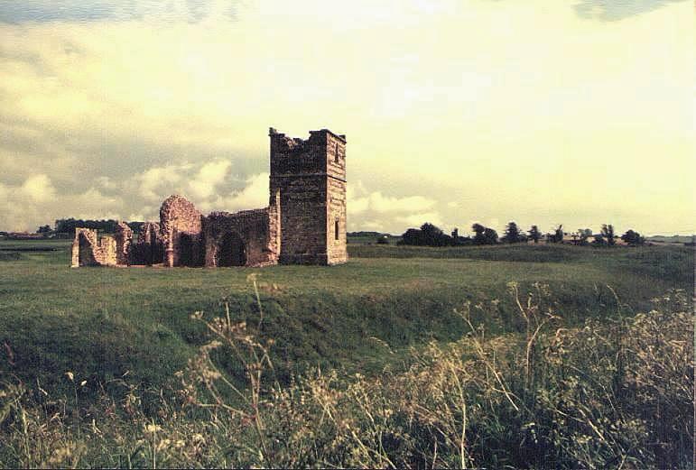
Knowlton Henge Church & Henge County: Dorset O.S. Grid Ref: SU 023 102 O.S. Map (Streetmap) Satellite Photo (Google Maps) Photo Size: 69 KB / Date: June 1991
At the centre of the henge is a 12th-century Norman church with a 15th-century tower. The church was most likely built within the henge in an attempt to consecrate it and rid the site of its pagan association. The North and South henges are only visible in aerial photographs. The Northern one is oval and the Southern is some 800 ft (244 m) across. To the East of the central henge is a tree-covered round barrow called the Great Barrow (SU 025 102) which is 134 ft (41 m) in diameter and stands 19� ft (6 m) high. |
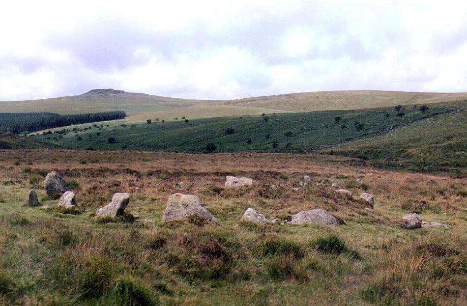
Hartor North a.k.a. Hart Tor, Har Tor Cairn-Circle & Stone Row County: Devon O.S. Grid Ref: SX 577 717 O.S. Map (Streetmap) Photo Size: 103 KB / Date: August 1987
The circle is 29 ft (8.8 m) in diameter and has a cairn at its centre. A double-row of stones leads away from the circle, downhill to the WSW. The 'avenue' has over 40 pairs of stones and is 450 ft (137 m) long and 6� ft (2 m) wide (part of it can be seen at the centre-right of the photograph). Hartor South (SX 576 716) is a single stone row 164 ft (50 m) long, also orientated ENE-WSW. The tor seen in the photograph is Sharpitor, 1.2 miles (2 km) distant. |
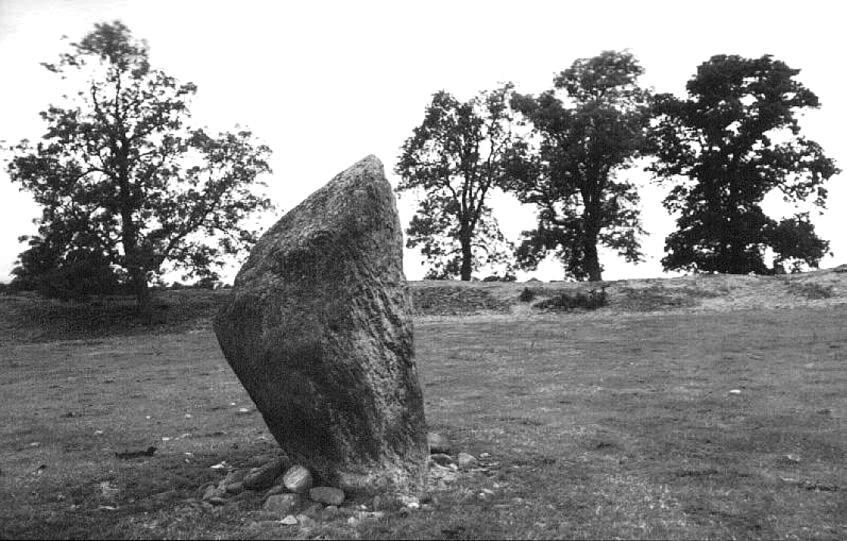
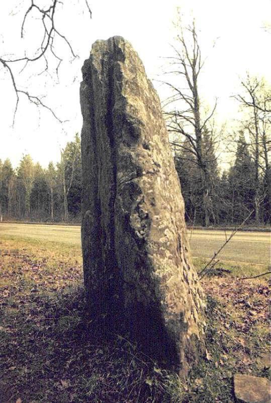
Long Stone, Staunton Standing Stone County: Gloucestershire O.S. Grid Ref: SO 559 121 O.S. Map (Streetmap) Photo Size: 99 KB / Date: February 1994
One of four stones in Gloucestershire having the name 'Long Stone', it is ca. 7 ft (2.2 m) tall and leans towards the South-east. There are two vertical grooves running down its South-eastern face. A local legend says that the stone bleeds when it is pricked with a pin at midnight (!) |
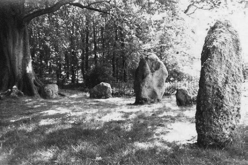
Nine Stones Stone Circle County: Dorset O.S. Grid Ref: SY 610 904 O.S. Map (Streetmap) Photo Size: 104 KB / Date: May 1990
The circle is elliptical in plan and measures 30 ft (9.1 m) by 26 ft (7.9 m). The stones are a mixture of sarsen and conglomerate. Most of them are barely 3 ft (1 m) tall but the two at the North-west are much larger, the tallest being nearly 6� ft (2 m) high and estimated to weigh some 8 tons (8,130 kgs). The pointed and flat-topped pair suggest an intentional male and female symbolism. British archaeologist Aubrey Burl has suggested that this circle has design parallels with the so-called recumbent stone circles of South-west Scotland, whilst stone circle researcher John R. Hoyle has noted numerous similarities between this circle and the much smaller Temple cairn-circle (SN 746 791) near Ysbyty Cynfyn in Ceredigion, Mid Wales. |
Hanging Stones Rock Carvings County: West Yorkshire O.S. Grid Ref: SE 128 467 O.S. Map (Streetmap) Photo Size: 83 KB / Date: July 1988
The designs, which are thought to date from the Bronze Age period, are carved into an extensive bedrock measuring about 85 ft (26 m) long by 19 ft (6 m) wide, with a sheer drop of about 26 ft (8 m) at its Northern edge. On the western end of the rock are two unusual figures, where use is made of cups and rings of varying sizes, with grooves enclosing or crossing the figures. A large groove runs from the northern to the southern edge of the rock. |
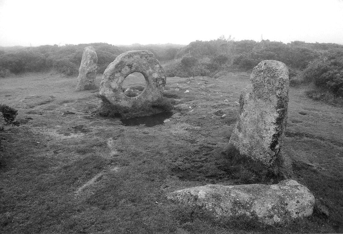
M�n-An-Tol Stone Setting County: Cornwall O.S. Grid Ref: SW 426 349 O.S. Map (Streetmap) Photo Size: 159 KB / Date: June 1991
The row is about 18 ft (5.6 m) in length; the two end menhirs stand 4 ft (1.2 m) tall and the central monolith is 3ft 7 in (1.1 m) high. The slightly elliptical hole is about 1 ft 6 in (0.46 m) across and has bevelled edges. It is said that children were once passed through the hole in order to cure rickets. It is possible that the present arrangement represents only the remains of a larger structure - perhaps a burial chamber, the circular stone having once been a porthole entrance to a chamber. The presence of a low cairn at the row's Southeastern side might also suggest an association with a burial. Early in the 20th century, astronomer Sir Norman Lockyer suggested that the stones were intended as 'sighting stones' to observe the rising Sun in early May and August (looking to the ENE) and the setting Sun in early February and November (to the WSW), which were important festival dates during prehistoric times. A word of caution is necessary here, however: at least one of the stones is reported to have been moved from its original position at some time before 1825. An excavation trench was cut between two of the stones in 1754, but only a flint flake was found. |
 Neolithic
Tombs in South Wales
Neolithic
Tombs in South Wales
Copyright Martin J Powell 2001 - 2015
 South
Dartmoor in 3D Stereo
South
Dartmoor in 3D Stereo A
Round Barrow in Gwent
A
Round Barrow in Gwent