|
|
|
|
|
| Archaeoastronomy in South Wales: |
| Stone Circles & Avenues |
Stone Circles & Avenues
by Martin J. Powell
There are eleven recognised stone circles in the South Wales region comprising Glamorganshire, Brecknockshire (i.e. Breconshire, South Powys) and Monmouthshire (Gwent). Five of the circles have previously been considered in an astronomical context by the late Professor Alexander Thom (Thom 1967, 101, Table 8.1). All five are located within the Brecon Beacons National Park in Powys, and they will now be briefly discussed.
At the Cerrig Duon circle in Fforest Fawr (SN 851 206) Thom suggested that the outlying stone (Maen Mawr) when viewed from the centre of the circle, indicated the rising of the star Arcturus in 1950 BC. A stone avenue leading to the circle is described on the Wales prehistoric sites photo gallery.
|
|
|
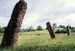
The 6 ft (1.9 m) high monolith known as Maen Mawr ('large stone') stands beside the Cerrig Duon stone circle, against the bleak backdrop of winter in the Brecon Beacons. |
For the two circles on Trecastle Mountain or Mynydd Bach Trecastell (SN 833 311), Thom proposed three solar alignments, the most significant being to the midwinter sunrise. In the early 1900s, Lt-Col. W. Llewellyn Morgan also suggested that a row of four small stones, some 60 ft (18 m) long, leading from the smaller, South-western circle was aligned towards the early February and early November sunset, i.e. the Celtic Iron Age festivals of Samhain and Imbolc (Llewellyn Morgan 1907-8, 148). However, British archaeologist Aubrey Burl thinks it unlikely that this "miserable alignment" could ever have been used for astronomical observation; the low-standing row was so deeply buried in the moorland that Thom failed to notice it when he surveyed the site (Burl 1976, 262).
Interestingly, the recent Royal Commission plan of the site shows an additional row of three stones running between the two circles, some 39 ft (12 m) long, tangential to their South-eastern edges and roughly on the same alignment as the aforementioned row (RCAHMW 1997, 154). The Royal Commission consider that these stones "if plotted out would lie upon a circumference of about 35 ft (10.6m) in diameter" (ibid., 153) and that they are "perhaps the remnants of a third small circle" (Leighton 2012, 95). Looking at the plan of the site, it is difficult to envisage a circle in this position, and it should be noted that a stone row running tangential to a stone circle is also present at the aforementioned site of Cerrig Duon, just 6½ miles (10.6 km) South of the Trecastle circles. The Ordnance Survey have, however suggested that at least some of these stones, together with others located further away from the circles, may once have formed part of a field boundary.
At the two elliptically-shaped Nant Tarw circles, situated South of the Usk reservoir (SN 819 258), Thom proposed four alignments, perhaps the most significant being between the centres of the two circles towards sunset on the Beltane/Lughnasa Iron Age festival days (i.e. early May/early August). There is a peculiar, closely-spaced 'stone setting' positioned 350 ft (107 m) to the WNW of the North-western circle, comprising three stones laid out in an East-West alignment. When seen on the skyline from the North-western circle, the largest of these stones (now fallen) indicates the setting point of the star Spica around 1900 BC. A similarly fallen stone on the WSW horizon, 280 ft (85 m) distant from the South-eastern circle, indicates a declination of -16°.8. Although Burl says this has no astronomical significance, it does in fact lie very close to the Samhain/Imbolc setting Sun (Burl 1976, 260).
|
|
|
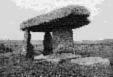
The First Piper standing stone beside the Gray Hill stone circle, near Llanvair-Discoed. Together with a second stone some 180 ft (55 m) distant, it forms an approximate alignment on the midwinter sunrise. |
In Monmouthshire, an astronomical alignment at the Gray Hill stone circle (ST 438 935) near Wentwood Forest, was first proposed by Fred J. Hando, a resident writer and artist (Hando 1944). He suggested an alignment on the midwinter sunrise, downhill towards the South-east, between two standing stones which he named the "First Piper" and the "Second Piper". The claim is disputed by Burl (personal communication 1990) on the grounds that the line is inaccurate and that another stone adjcent to the circle has been overlooked in the assessment. However, a distinctive 'notch' on the distant skyline to the South-east, 'formed by the gorge of the River Avon', adds weight to the solsticial alignment claim (Chadwick & Pollard 2010, 102). For more details of this site, see the Wales prehistoric sites photo gallery.
The lonely circle at Ynys Hir (SN 921 383) on Mynydd Eppynt (now within a military training area) is an interesting circle with an apparently natural group of boulders occupying a wide gap at its South-eastern edge. Another wide gap occurs at the West of the circle. After excavation in 1940 the excavator thought that the most likely reason for the placement of these entrances was to accomodate two prehistoric trackways which intersected a short distance away from it (Dunning 1943, 178). One of the tracks was orientated East-West, and the entrances to the circle were similarly arranged, allowing easier access to the circle. However, when considering the deliberate inclusion of the natural boulders in the circle, he stated that "the long gap [at the South-east of the circle] suggests that the group [of boulders] was, for some reason or other, intentionally incorporated in the plan of the monument" (ibid., 177). The Royal Commission's recent inventory of the region states that these "glacial erratics were probably left there because they were too heavy to move" (RCAHMW 1997, 157). Could astronomy help to explain the inclusion of these stones? Although the centre-point of the boulders, when viewed from the centre of the circle, indicates sunrise in late November and mid January, the arc spanned by the boulders also takes in the midwinter rising Sun - which may have been the builders' intended target.
The largest circle in the study area is the now barely discernible Blaen Digedi circle South of Hay-on-Wye (SO 239 373), also known by the names Hay Bluff, Blaenau and Pen-y-Beacon. The site was long suspected to be ancient but was not positively identified as a stone circle until 1970. It is particularly accessible since it stands beside a public car park on the road passing the Hay Bluff escarpment. Some recently placed boulders confuse the site somewhat, however the original circle was some 98 ft (30 m) in diameter, but only one original stone is now visible. This stone is of particular interest since, together with a smaller adjacent stone, it is set at right-angles to the circumference of the circle, the pair forming an apparent 'entrance' to the circle at the South-east (RCAHMW 1997, 160). A possible cup-mark (man-made circular hollow) has been identified on one of the stones, measuring 2.7 inches (7cm) in diameter and 1.2 inches (3cm) deep. It is positioned just below an Ordnance Survey benchmark indicating a height above mean sea level of 470 m (1542 ft) (Children & Nash 2001, 125-6).
|
|
Three 'new' stone circles in the study region have officially been recognised as such since 1979. Situated to the South of the Elan Valley about 0.9 miles (1.5 kms) South-east of the Caban-Coch Reservoir, the Crugiau Bach stone circle (SN 931 624) is 69 ft (21 m) in diameter with a marked 'flattening' on its North-eastern side. It comprises 21 stones, only seven of which are upright, although the original number was probably at least 40. Most of the visible stones are low-standing, the tallest being just 2.3 ft (0.7 m) in height. There is a recumbent slab at the circle's centre, perhaps indicating a cist burial. A standing stone (outlier?) of low height is positioned about 246 ft (75 m) to the North-east of the circle (Heath 2010, 83). A plan and photograph of this site appears in the Clwyd-Powys Archaeological Trust's Spring 2009 newsletter. Intriguingly, the Crugiau Bach circle escaped the attention of the Royal Commission in their 1997 Brecknock inventory, who only listed a handful of cairns a short distance to the North of the circle.
|
|
|
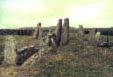
The only clearly visible stone at the Blaen Digedi stone circle, West of Hay Bluff. At 98 ft (30 m) diameter, it is the largest circle known in South Wales. |
Discovered in 1993 by a local resident, the Banc y Celyn stone circle (SO 050 463) is situated on open moorland to the South of Builth Wells. It is elliptical in plan, measuring 60 ft (18.5 m) by 49 ft (15 m) in diameter. There are 24 stones, three of which are clearly visible uprights, the remainder being partially visible or completely hidden beneath the vegetation. Like at Blaen Digedi, it has an entrance-like stone setting at the South-east (RCAHMW 1997, 158).
The Llorfa stone circle (SN 786 155) lies on the Southern edge of the Black Mountain range, about 6.2 miles (10 kms) North of Ystradgynlais. The site was discovered in 2006 during fieldwork conducted by the Clwyd-Powys Archaeological Trust (see a plan and photograph of the site in CPAT's Spring 2009 newsletter). It measures 33 ft (10.2 m) by 31 ft (9.5 m) and comprises around 20 small stones, standing no taller than about 2 ft (0.6 m). There are large gaps in both the Eastern and South-western sectors. CPAT reports that "the tallest stone may originally have been on the south-east where a recumbent slab could have stood to perhaps 0.6 m". The site plan also shows two large stones positioned opposite each other on an ENE-WSW axis. Like at Ynys-Hir, the Llorfa circle incorporated natural boulders within its construction (Leighton 2012, 95).
Just across the border in Carmarthenshire, 1.1 miles (1.8 km) South-west of the Nant Tarw circles, is the ruinous stone circle of Sychnant, also known by the names Bannau Sir Gaer and Waun Lwyd (SN 808 244). Although it is outside the study area this circle deserves mention since it is both geographically and morphologically related to the other circles in the region. Discovered in 1977, it is 60 ft (18.3 m) in diameter and contains at least 18 stones with two possible outliers positioned to the North-west of the circle. Whilst most of the stones are less than 1 ft (0.3 m) high, the largest stone - which occupies the South-eastern quadrant - stands 2 ft 9in (0.85 m) high. The Royal Commission's online database states that this stone "is surrounded by other large stones ... [which] may possibly represent a former single upright considerably larger than the other stones of the ring" (RCAHMW 2008). Alternatively these fragments may be the remains of a stone setting, similar to those found at some other circles described above.
The presence of stone settings or wide gaps in the South-eastern quadrant of numerous stone circles in South Wales is potentially of considerable archaeoastronomical interest. Stone settings at the South-east occur at the Nant Tarw Western circle, the Trecastle Eastern circle, Ynys-Hir, Blaen Digedi, Banc y Celyn and perhaps at Crugiau Bach. Tallest stones occupy the South-eastern quadrant at both Llorfa and Sychnant. Curious gaps in the South-east, which may mark the former presence of stone settings, are present at Cerrig Duon and Nant Tarw East. These sites certainly require further astronomical study.
Finally, a stone circle marked on Ordnance Survey maps at Rhyd-wen Fach (SN 822 231), some 1.1 miles (1.8 km) South-east of the Sychnant circle, is probably a natural collection of boulders (Leighton 2012, 171).
Survey Results (Explanation of Data Table)

Copyright Martin J Powell 2001-2017
| Archaeoastronomy in South Wales: |
| Stone Circles & Avenues |
BIBLIOGRAPHY
BURL, Aubrey
1976 The Stone Circles of the British Isles (Yale University Press, New Haven & London).
CHADWICK, Adrian M. & POLLARD, Joshua
2010 "The Gray Hill Landscape Archaeology Project, Llanfair Discoed, Monmouthshire, Wales" in Lewis, Helen & Semple, Sarah (eds.), Perspectives in Landscape Archaeology (BAR Publishing, Oxford), pgs. 94-106.
CHILDREN, George & NASH, George
2001 Prehistoric Sites of Breconshire (Logaston Press, Woonton Almeley).
DUNNING, G. C.
1943 "A Stone Circle and Cairn on Mynydd Eppynt, Brecknockshire" in Archaeologia Cambrensis (The Cambrian Archaeological Association, Cardiff), pgs. 169-194.
HANDO, Fred J.
1944 The Pleasant Land of Gwent (R. H. Johns Ltd., Newport).
HEATH, Julian
2010 Sacred Circles: Prehistoric Stone Circles of Wales (Llygad Gwalch, Pwllheli).
LEIGHTON, David
2012 The Western Brecon Beacons: The Archaeology of Mynydd Du and Fforest Fawr (RCAHMW, Aberystwyth)
LLEWELLYN MORGAN, Lieut.-Col. W.
1907-8 "Three days with the Swansea Scientific Society" in Transactions of the Swansea Scientific Society, pgs. 145-162.
ROYAL COMMISSION ON THE ANCIENT & HISTORICAL MONUMENTS OF WALES
1997 Brecknock: Later Prehistoric Monuments and Unenclosed Settlements to 1000 A.D. (Sutton Publishing Ltd., Stroud).
2008 COFLEIN online database; site description for NPRN 92909
THOM, Alexander,
1967 Megalithic Sites in Britain, Oxford University Press (Oxford).
|
|
|
|
|
|
|