|
|
|
|
|
The Orientations of
Neolithic Chambered Tombs
in Glamorgan and Gwent Counties
by Martin J. Powell
Introduction
The chambered long cairns that are the subject of this study form the western extremity of a class of Neolithic chambered tomb referred to as the Cotswold-Severn group. They are typified by their relatively small chambers set within a long trapezoidal or oval shaped cairn, one end from which opens a cusp-shaped forecourt defined by two protrusions or 'horns'. The chambers may be set either terminally (immediately behind the forecourt) or laterally (opening from the sides of the cairn). The tombs are thought to have been constructed during the early to middle Neolithic period in Britain, i.e. throughout the fourth millennium BC. Few have been thoroughly excavated and the poor condition of many of those remaining often prohibits a definitive assessment of their original form. Most have now lost their covering cairns and the only visible feature is the chamber proper.
The tombs under study occupy the lowland region of the South Wales seaboard from the Gower peninsula in the West, across the Vale of Glamorgan to Gwent in the East. Their geographical locations are shown in Figures 1 and 2.
The majority of tombs in this region are terminally chambered; the remainder are of miscellaneous type. A number of them are in a sufficiently good condition for their orientations to be recovered with reasonable accuracy and then studied as a group. This assessment will seek to establish whether any favoured orientations can be recognised in the group, and if so whether astronomical events can be proposed to partly or wholly explain them.
|
|
|
Figures 1 & 2 Map of Wales showing the location of Neolithic tombs under study, with an enlarged map of the Gower peninsula (Fig 1) and Glamorgan and Gwent counties (Fig 2) (click for larger image). The site designations are those as given in Table 1. |
Measurement Methods
Eleven tombs have been selected on the basis of condition and the existence of a good published site plan. In all cases plan orientations were checked on-site by magnetic sighting compass. Compass accuracy was tested at each site by reference to distant identifiable features whose bearings were later calculated from Ordnance Survey maps. Consequently the compass is believed to be accurate in most cases to within ± 1°. No sites are in a good enough condition for their orientations to be recovered to any greater accuracy than this. The axis of a tomb is defined here as the average bearing of the cairn sides in the direction of the chamber (where the entire plan is known) or of the chamber sides in the direction of the entrance (where the plan of the cairn is uncertain). The bearings thus determined are given here to the nearest tenth of a degree.
Horizon and site elevations were in all cases determined from 1:25,000 scale Ordnance Survey maps, hence they are subject to inaccuracy. All declinations have been calculated taking the necessary allowances for refraction and assuming an observer's eye height of 1.549m (5ft 1in) above the cairn ground level. The horizon is assumed to be free of vegetation cover.
Tombs under study
Generally the tombs are well spread across the study region but two main groupings can be identified on geographical grounds, namely the Vale of Glamorgan and Gwent group and the Gower group.
Details of the tombs under study are given below together with the source of the site plan and the Ordnance Survey Grid Reference.
1. The Vale of Glamorgan and Gwent group
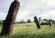
Tinkinswood (Ward, 1915) ST 09207 73300: 1 km South of St. Nicholas, South Glamorgan. This well-known site would also appear to be the largest in the survey, the rectangular cairn being 40m long by 17.8m maximum width (Figure 3). A large rectangular chamber 5m by 3.5m occupies the Eastern end of the cairn, although the Southern side supporter has gone. The entrance to the chamber was constricted by dry-stone walling to a slab-lined passage 0.8m wide. The capstone covering the chamber is massive and is estimated to weigh some 40 tons. The tomb was excavated and restored by J. Ward in 1914; the bones of some 50 individuals were represented.
The relatively straight and nearly parallel sides of the cairn provide a good azimuth of nearly 73°. This may be assumed to be the intended axis of the chamber proper. The horizon in this direction is local, facing a small featureless hill about 0.5 km distant. The elevation is nearly 1°.4 and this gives a declination of +11°.3. The star Altair in the constellation of Aquila attained this declination around 3450 BC, but this would seem an unlikely target for the cairn builders [Photo].
Maes y Felin (RCAHM, 1976, No. 42) ST 10095 72300: 1 km Southwest of St. Lythans, South Glamorgan. A chamber comprising three side supporters and a capstone stands at the Eastern end of a much denuded long mound about 27m long by 11m wide. The chamber dimensions are 3.5m long by 2.5m wide (Figure 3).
The side slabs of the tomb diverge considerably and consequently a clean azimuth cannot be obtained. The average direction of the irregular mudstone side slabs is 96°. The horizon is close, being an extension of the same elevated land upon which the chamber stands. The calculated altitude is 2°.6, which results in a declination of -1°.8. The Sun reaches this declination close to the equinoxes in March and September. The star Antares in the constellation Scorpius attained this declination around 3360 BC [Photo].
Tythegston (RCAHM, 1976, No. 37) SS 86467 79255: 1.2 km Southwest of Laleston, Mid Glamorgan. Only the mound and the capstone of the chamber are immediately evident at this site. Inspection beneath the capstone, however, reveals the existence of a side supporter at least 0.5m long on the tomb's Southern side. The chamber is rubble filled. The grass-grown mound is oval, standing 1.2m high and measuring about 27m long by 18m wide (Figure 3).
Although only approximate, an azimuth can be derived via the side supporter and the capstone sides. The axis thus defined is about 69°. [Photo]
The tomb is located near the summit of a broad hill with extensive views in nearly all directions. The axis line faces over the town of Laleston to a distant hill (Mynydd Meiros) which forms part of the Southern boundary of the Rhondda valleys. The elevation is 0°.5, giving a declination of +12°.9.
|
Figure 3 Site plans of three Neolithic long cairns in the Vale of Glamorgan (click for larger image). Top: Tinkinswood (after Ward); Centre: Tythegston (after the Royal Commission) and Bottom: Maes y Felin (after the Royal Commission). In this and other figures, earthfast stones are shown solid, capstones by dashed lines and loose stones in outline. Approximated or reconstructed sections are shown by dotted lines. |
|
|
Figure 4 Neolithic tombs in Glamorgan and Gwent (click for larger image). Upper Left: Heston Brake (after Bagnall-Oakeley); Upper Right: Gaerllwyd (after Webley); Centre Left: Pen-Maen Burrows (after the Royal Commission); Centre Right: Maen Ceti (after the Royal Commission); Bottom Left: Cae'rarfau (after the Royal Commission) and Bottom Right: Nicholaston (after Williams). |
|
|
|
Cae'rarfau (RCAHM, 1976, No. 41) ST 07737 82145: 0.75 km Northwest of Creigiau, Mid Glamorgan. A small, damaged chamber 2m by 2m stands against a field wall that partly supports it (Figure 4). No traces of a mound are now visible but apparently the chamber once stood at the Northern end of a long mound (Lukis, 1875). [Photo]
The side slabs of this chamber are small, irregularly shaped and converge toward the entrance, making recovery of an axis azimuth very difficult. It is orientated very close to due North and faces a low hill near Upper Church Village 4.8 km away. The elevation of 1°.3 gives a declination of +39°.4. This is well outside the range of the Sun or Moon and since the declination is greater than the co-latitude of the site (38°.47) the stars in this direction are circumpolar, although no bright stars are indicated.
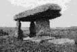
Heston Brake (Bagnall-Oakeley, 1889) ST 50525 88667: 0.6 km Northeast of Portskewett, Gwent. Several low standing and weather-beaten orthostats form the remnants of a chamber and passage 8m long by 2m wide (Figure 4). The long mound is orientated E-W and is at least 21m long. The passage entrance is defined by two portal stones, but no capstones survive. The axis of the passage is offset in relation to that of the chamber at the point where they join, although they share a common orientation; this feature may be indicative of a two-period structure (Corcoran, 1969, 45). A minor excavation was undertaken in 1888.
Despite the rugged and overgrown nature of the stones, their parallel positioning enables the axis to be recovered with reasonable accuracy.
The tomb stands on a low hill overlooking the Severn Estuary. The chamber axis of 93°.7 faces across the Estuary to land some 26.8 km distant in the county of Avon. The declination indicated is -2°.5 [Photo].
Gaerllwyd (Webley, 1961) ST 44760 96745: In Gaerllwyd hamlet, Gwent. The site is also known as 'Y Garn Llwyd'. The original layout of this tomb is uncertain because much of the chamber's supporting structure has been robbed away; the capstone is propped against the portal stones at a steep angle, having slid off the end stone of the chamber (Figure 4). The chamber probably would have measured about 4.5m by 3m, but any traces of a mound have disappeared. Two portal stones are set transversely at the entrance and each is accompanied by a further stone set in line with the chamber axis; the latter feature may be the remnants of a simple forecourt structure. The tomb does not have clear parallels with the Cotswold-Severn tradition and would seem to owe more to the type of dolmen found in West Wales [Sketch].
The axis of the chamber has in this case been taken as the line perpendicular to the transverse portal stones, which more or less coincides with the line defined by their associated 'forecourt' stones.
The chamber stands at the head of a valley and its axis faces down the valley toward the Severn Estuary. A deliberate orientation of the tomb along the valley might therefore be suspected. The altitude of the chamber is the highest in the survey region and since the horizon is 34 km away in Gloucestershire the elevation of the horizon is a low -0°.16. The declination is then -6°.2.
|
|
2. The Gower Group
The first two tombs listed here are referred to as transepted terminal chambers, whereby the presence of a main chamber is replaced by small side chambers branching off at right angles to an axial passage.
Parc Cwm (RCAHM, 1976, No. 36) SS 53727 89832: 1.25 km Northwest of Parkmill, West Glamorgan. Also referred to as 'Parc le Breos Cwm', this site was uncovered by workmen removing stone in 1869. The long cairn measures 22.2m long by 12.4m maximum width (Figure 5). The passage is 6.2m long by 1m wide, and two pairs of side chambers open from it. Their average dimensions are 1.6m long by 1m wide. No capstones have survived, and it has been suggested that the roofing may have been entirely corbelled.
The remains of some 20 to 24 individuals were found at this site judging by the 1869 excavations, at which time the excavator thought that the cairn was oval in plan (Lubbock, 1871). The tomb was re-excavated from 1960-61 and restored, although the excavation report did not appear until almost 40 years later (Whittle & Wysocki, 1998). The number of individuals found was later revised upwards to around 40. Radiocarbon dating of bone from the tomb suggests a construction date between the earlier and middle part of the fourth millennium BC. This is the only tomb in the survey area to have been dated in this manner.
The cairn is the only one in the survey whose entrance faces South. The line of the passage is not well defined, however, because the stones forming its sides are not cleanly aligned. The Royal Commission gives the cairn axis as 185° and this was confirmed by compass measurement at the site. Since the axis is fairly close to due South an approximate alignment upon the meridian might be suspected.
The cairn stands inconspicuously in a narrow wooded valley. Its orientation essentially matches that of the valley. Interestingly, the cairn builders could easily have retained a more typical Easterly orientation by siting the tomb some 100 metres further South of its present site, at which point the valley veers sharply towards the East and there is no restriction of space necessary for construction. The horizon along the axis is only 170m distant and is heavily wooded; the approximate elevation is 7°.0, which gives a declination of -31°.3. This is too far South for the Sun but with a lunar declination of -30°.4 the 'post-transit' Moon might be considered the focus of attention (maximum Southerly declination -29°.2). More precisely, an alignment on the Moon's lower limb could be proposed if the 0°.9 error in declination is allowed [Photo].
Pen-Maen Burrows (RCAHM, 1976, No. 35) SS 53157 88120: 0.6 km Southeast of Penmaen, West Glamorgan. A good part of this monument is concealed by the large sand dune that surrounds it. The chamber structure itself is discernible, however, and comprises a main chamber (partitioned from the entrance passage by two transverse slabs) and probably originally two side chambers leading from either side of the main. A large capstone stands displaced atop the main chamber, the latter being ruinous on its Northern side and measuring 4m by 2m. The Southern side chamber measures 2.6m by 1.4m; that on the North has disappeared, if indeed it ever existed (Figure 4).
The entrance to the chamber is formed by parallel side slabs 2.4m long, which together with the main chamber define a fairly clear axis line to the South of East. The immediate horizon is very close and hummocky in nature; since it is formed of sand dunes it is now impossible to determine its original form and whether or not the distant horizon was visible from the level of the tomb at the time of construction. Were the dunes not present the horizon would be level at a distance of 2.3 km; the elevation would be just 0°.3 and the declination -5°.3. The presence of a close sand dune would increase the declination algebraically by a significant amount [Photo].
Nicholaston (Williams, 1940) SS 50760 88782: 1.9 km West of Penmaen, West Glamorgan. The smallest tomb of the survey is perhaps best described as a cist, since it measures just 1.2m by 0.9m. Two portal stones define a narrow entrance at the Northeast, and the floor area is paved. The cist carries two small capstones (Figure 4).
The cist stands at the centre of an overgrown mound 37m long by 20m
wide, standing up to 1.2m. Excavation in 1939 showed the mound to
consist largely of peaty soil, although a kerb of large stones defined
its edge. There was no evidence of a passage leading through the
mound to the cist.
|
|
|
Figure 5 Two long cairns in the Gower (click for larger image). Left: the ruined Sweyne's Howes South and Right: the restored Parc le Breos Cwm (both after the Royal Commission). |
Although small, the side-slabs of the cist are set parallel to each other and define a clean axis azimuth of 41°.3, which faces the Southern slope of Cefn Bryn 310m distant. Viewed from the tomb the hill slopes gently downwards towards the East but there are no prominent features upon which the tomb may have been orientated. The horizon elevation along the axis line is a steep 9°.5, yielding a declination of +36.0. The bright star Deneb in the constellation Cygnus lay close to this declination throughout the fourth millennium BC, although it would seem an unlikely target. The declination is too far North for either the Sun or the Moon [Photo].
The final two tombs have no clear affinity with the Cotswold-Severn tradition. More likely their origins lie further to the West.
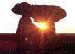
Maen Ceti (RCAHM, 1976, No. 33) SS 49130 90535: On Cefn Bryn, 1.3 km Northeast of Reynoldston, West Glamorgan. Also referred to as 'Arthur's Stone'. The most remarkable feature of this crude tomb is the capstone. It is a massive block of conglomerate and originally measured 4m by 3m by 2.2m high; a section of it has fallen and rests aside the tomb (Figure 4). The capstone itself was originally a natural boulder resting at ground level. The builders then created a hollow by removing the stones from around and beneath it and underpinning the block, which then served as a capstone. Nine blocks form the outline of the chamber and a further two serve as a partition dividing the enclosed area into two. A large block lies a metre away to the South and would have served as a backstone for the chamber. A vague circular cairn surrounds the tomb and it may never have been very substantial.
The axis line of the monument is surprisingly recoverable. The only clear entry point would have been through a gap barely 0.4m wide at the Northwest corner. The chamber is also widest at this point. After attempted reconstruction of the broken section of the capstone the axis line has been determined as the average direction of the reasonably straight capstone sides. The line looks over Northern Gower and the Loughor estuary to Mynydd Llangyndeyrn in the county of Dyfed 21.4 km distant. The elevation is just 0°.06, giving a declination of +37°.4. This is too far North for the Sun or the Moon, and no bright stars are indicated [Photo].
Sweyne's Howes South (RCAHM, 1976, No. 32b) SS 42097 89815: On Rhosili Down, West Glamorgan. This is a very ruinous site and little structure is visible on the surface; however a sufficient number of earthfast stones remain to enable the original plan of the cairn to be discerned. The cairn is irregularly shaped, measuring 20.7m by 14.9m and comprises an inner and outer spread of boulders (Figure 5).
No chamber survives, but a group of several loose slabs at the Northern end of the cairn probably represents its former location. Two earthfast slabs at the Northwest corner of the cairn seem to represent the remnants of a crescentic forecourt and two loose slabs occupy a similar position on the Northeast corner.
Reconstruction based upon the earthfast stones of the inner cairn allows an axis to be recovered with limited accuracy. At 351°.2 it is essentially the same axis as that for Maen Ceti. The line faces the Northern extremity of Rhosili Down, the horizon being some 180m distant. Viewed from the cairn the hill slopes steadily downwards towards the North; the elevation at the axis point is 2°.2 and the resulting declination is +39°.8. Again this is outside the range of the Sun or Moon; the stars are circumpolar at this point, although no bright ones are indicated.
Rejected Sites
Several monuments in the survey region are considered too ruinous for inclusion in this assessment, but their general orientations are nonetheless worthy of note. All except one are listed here with their Inventory Numbers from the Royal Commission's Inventory of Glamorgan (RCAHM, 1976).
Sweyne's Howes North (No. 32a, SS 4211 8991) stands about 100m away from the Southern cairn. The cairn is roughly oval in plan on a WNW-ESE orientation and a small tomb is eccentrically placed at the Northwest corner. The direction of the tomb's entrance is unclear [Photo].
The tomb near Carn Llechart (No. 31, SN 6966 0627) is of doubtful status and its form is unclear; the Royal Commission considers the entrance to face to the Northeast.
The chamber known as Coedparcgarw (No. 39, SS 9269 8193) is badly damaged but seems to have faced downslope to the East, whilst the Cae'reglwys cairn (No. 38, SS 9169 6824) has lost its chamber (which is only recorded in antiquity) and there are now few surface indications. The Royal Commission gives the cairn bearing as 277°. Similarly a long mound of uncertain status near Laleston (No. 44, SS 8677 8067) is given a bearing of 85°.
A stony long mound once existed at Upper Killay in the Gower (No. 43, SS 5848 9227) on a NNE-SSW orientation, but it was destroyed at some time prior to 1965.
In Gwent, the Gwern-y-Cleppa tomb (MON 1, ST 2759 8503) stands at the Eastern end of a possible long mound. The form of the chamber cannot be discerned [Photo].
Analysis of Group Orientations
The orientations of the eleven tombs under study have been plotted on an azimuth diagram (Figure 6). Whilst the range of orientations covers over half of the horizon, certain favoured directions can be identified.
Figure 6 Azimuth Diagram of tomb orientations in Glamorgan and Gwent (click for larger image). Approximate azimuths of solar and lunar events are shown as follows: MaNMR/S - Major Northern Moonrise/set, MSSR/S - Midsummer Sunrise/set etc. CQbl/si indicates the Beltane/Lughnasad and Samhain/Imbolc cross-quarter days. Marked in 10 degree increments. |
|
|
Figure 7 Bar chart of declinations indicated by the tombs under study (click for larger image). Declination is shown on the vertical axis; negative values are to the left and positive to the right. The bin width is 2°. |
|
|
|
The most notable group of seven lines (64% of the total) occurs between azimuths 41° and 99°, i.e. within 16% of the horizon. Four lines cluster within this group in an arc 5°.4 wide just South of East. Three of these lines are assigned to the Vale of Glamorgan and Gwent group.
Of the remaining lines, three face within a 7 degree arc just West of North and one line faces South. All but one of these lines are assigned to the Gower group.
Other than the Southerly line, no orientations occur in the arc from azimuths 100° through 351°. The Western half of the horizon was clearly avoided by the cairn builders in South Wales.
The orientations are therefore significant in mainly occupying an arc between azimuths 351° and 99°, i.e. 30% of the horizon. All cardinal points except West are represented, although most alignments upon these are by no means precise.
Analysis of Indicated Declinations
The declinations indicated by the tombs are displayed in bar chart form in Figure 7. The bars are shown in 2° bins. Two groupings are immediately evident.
The first group of four bars occurs in the declination range +36° to +40°; three of these are attributed to the Gower group and they lie well outside the range of the Sun or Moon. A second group of four occurs between declinations 0° to -8° and a further two between declinations +10° to +14°. All but one of these lines occur in the Vale of Glamorgan and Gwent group and since the Sun attains these declinations during the course of the year they shall be discussed in further detail below.
|
|
An isolated bar occurs at the -30° to -32° declination bin. This line represents Parc Cwm in the Gower group and has already been discussed.
Apart perhaps from the latter line, none of the recognised significant solar or lunar declinations are represented in these results. The nearest significant declination encountered is that of the equinox, to which Thom assigns a value of +0°.4 based on data for Bronze Age monuments (Thom, 1967, 110). This value is approached by the tombs only to within 2°.2. The May/August cross-quarter day declination defined by Thom (also on Bronze Age data) is +16°.6 and the tombs only approach this value to within 3°.7.
Indicated Calendar Dates
The declination of the Sun during the fourth millennium BC lay between +24° and -24°. Since six lines have declinations falling within this range, they shall now be studied in terms of the calendar dates at which the Sun attains the relevant declination.
All but one of the lines pertain to the Vale of Glamorgan and Gwent group. The Gregorian calendar dates for the six lines are listed in Table 1. Twelve dates are given because, with the exception of the solstices, the Sun attains any given declination twice in the course of a year. The dates given are for the declinations quoted, but the uncertainties in azimuth would mean that the true dates could lie within about four days of those given.
The results are worthy of note. The lines concentrate over a seven week period in both the Spring and Autumn seasons. Within this period, two small groupings can be identified.
The first grouping of four lines has declinations a short distance South of the celestial equator and the dates for these range from 5 to 16 March with corresponding dates from 28 September to 9 October, i.e. a period of two weeks in each case. This grouping is significant and would not be expected to occur by chance even if, as might be suspected, the tombs were only roughly orientated in an Eastward direction. The grouping could be interpreted as an attempt by the cairn builders to orientate the tombs towards a locally determined equinox, i.e. centred around a declination of about -4°. The calendar dates would then occur around mid March and early October, or about ten days away from the true equinox dates. Since the daily rate of change of solar declination is greater around the equinoxes than at any other time of the year, the equinoxes would have been the most difficult solar event for the tomb builders to pinpoint. Even if the equinoxes were not the intended target, the grouping of four lines over a two week period is nonetheless significant and is perhaps indicative of festival dates in their own right.
The second grouping of two lines indicates dates between 20 and 24 April with corresponding dates from 19 to 24 August. These dates lie two weeks away from the Celtic festival days of Beltane and Lughnasad, although the close proximity of the dates indicated by the tombs is also suggestive of festival days in their own right. Interestingly both of these tombs are in the Vale of Glamorgan.
It is worth noting that two tombs in the Vale of Glamorgan (Tinkinswood and Maes y Felin), whilst only 1.3 km apart, do not indicate close calendar dates. Rather, the dates indicated by these typologically similar tombs differ by about a month.
The Samhain and Imbolc festivals of November and February and the summer and winter solstices are nowhere represented.
Conclusion
The chambered tombs of Glamorgan and Gwent show considerable diversity in both design and orientation. However the Gower in particular has a greater diversity overall than those in the Vale of Glamorgan and Gwent.
The untypical Northerly orientations of the tombs in Western Gower are worthy of brief discussion. It has already been mentioned that the orientation of the Maen Ceti tomb was determined by the random orientation of the natural boulder that later served as its capstone. An astronomical target cannot be found for this tomb, and such is the case for the Sweyne's Howes South cairn. The latter cairn lies 7.2 km to the West of Maen Ceti and has a nearly identical orientation. Perhaps it dates from a later period than Maen Ceti and was deliberately set to match its orientation, in accordance with a local tradition. Alternatively, both of the Sweyne's Howes tombs may be orientated in the direction from which their design-types originate, i.e. across the Loughor estuary in Pembrokeshire, implying a strong element of ancestor worship. These tombs certainly seem to owe much to the Portal Dolmen culture of West Wales and the Irish Sea provinces.
The two transepted tombs in the Gower have widely varying orientations. Pen-Maen Burrows has an orientation in accordance withthose of the Vale of Glamorgan and Gwent group whilst Parc Cwm was aligned in conformity with the sides of the valley in which it stands. The Gaerllwyd chamber in Gwent is also aligned with a valley, but only further research can establish whether tombs in valley locations share this trait and indeed whether astronomical alignments were a consideration in these cases. Both of these tombs appear to support this notion.
With the possible exception of Parc Cwm, the Moon does not appear to have been a focus of attention for the tomb builders in South Wales. The Sun is the most likely target, with six of the eleven tombs facing some point on the horizon at which the Sun rises during the year. Interestingly most tombs in the Vale of Glamorgan and Gwent indicate solar dates in relatively narrow time periods during the Spring and Autumn seasons; it may be inferred from this that tomb construction took place during these seasons. The equinox may have been a reference point for the tomb builders, although it is not indicated anywhere in the region precisely. The solstices are nowhere indicated. The Cae'rarfau chamber seems to have been intentionally aligned towards due North, but no obvious target can be found for the cist-like chamber at Nicholaston.
Most of the tombs under study face level or gently sloping horizons. None of them are aligned towards any prominent geological features or 'notches' which could have been intended to pinpoint an astronomical event with precision. This does not necessarily weaken the astronomical argument for these tombs. It has been mentioned that the number of tombs facing the Eastern half of the horizon exceeds what may be expected by chance. Their orientations were sufficiently precise for determining ceremonial dates, possibly to within a week.
The tombs studied in this assessment account for only about 6% of the total number of recognised tombs of the Cotswold-Severn tradition, which are spread across eleven counties in England and Wales. In 1950 Daniel published a persuasive diagram showing the orientations of the tombs in this group, however the number of tombs he plotted is nowhere near the true total (Daniel, 1950, 80). Clearly a great deal more research is needed into the astronomical potential of the Cotswold-Severn group. This would provide a much clearer picture of favoured orientations and establish whether they were adhered to on a local or on a wider, regional basis. It should also help to fix the revered calendar dates that the prehistoric folk apparently indicated through their burial monuments.
Copyright Martin J Powell February 1993
A Note on the Thornwell Farm Chambered Tomb, Chepstow
|
|
|
Thornwell Farm chambered tomb, looking South-west towards the Severn Estuary (click for a larger image). The stone in the foreground is one of two constricting stones which demarcate the entrance to the chamber; the other can be seen to its right, just protruding above the surface. |
In 1990 a Neolithic chambered cairn was discovered prior to the development of a residential housing estate near Thornwell Farm to the South of Chepstow (ST 5394 9167), at the Eastern extremity of former Gwent county (now re-named Monmouthshire). The site was examined in 1991 by the Glamorgan-Gwent Archaeological Trust and a report on its findings was then issued (cited in Children & Nash, 1996).
The site is located about 0.46 km (0.28 miles) East of Junction 2 on the M48 motorway (Chepstow junction). The cairn appears as a low grass-grown tump beside Fountain Way, topped by an old oak tree, whose roots have apparently caused considerable damage to the interior structure of the site. Some stone kerbing can be seen around the perimeter of the cairn. Only a handful of the chamber orthostats can be seen protruding above the present surface level, but they are sufficient in number to allow the form and orientation of the chamber to be discerned.
The single chamber measures 2.1m long by 1.1m wide and is separated from an antechamber by two slabs set transversely at its entrance, which would originally have restricted access to the chamber. The remains of four adults and two children were found in the tomb, along with early Neolithic pottery and flint tools, and a large quantity of bones from birds of prey. The cairn surrounding the chamber was only partially explored, but it measures about 16m by 10m. GGAT considers the tomb to belong to the Severn-Cotswold tradition.
The site's location, on a hillock overlooking the Severn Estuary, is similar to that of Heston Brake 4.5 km (2.8 miles) to the South-west. The orientation of Thornwell, however, is markedly different to Heston Brake in that the chamber is orientated to the NNE - the only Neolithic chamber in the Glamorgan-Gwent region to face this sector of the horizon. The sides of the chamber are almost parallel, giving a fairly clean azimuth of about 29°.5 (this incidentally differs from the published plan of the tomb, which gives the chamber a more or less due East orientation). The chamber entrance faces higher land less than 100 metres distant; however the view in this direction is now obstructed by the housing estate, causing difficulty in determining the horizon elevation, which is around 3° or more. The resulting solar/stellar declination is about +35°, with a considerable margin of error. Regardless of the uncertainty in the declination, it is nonetheless clear that the tomb faces a direction well outside the range of the rising Sun and Moon. Much like the North-easterly facing chamber at Nicholaston far away to the West, Thornwell has no obvious astronomical association.
Two Early Bronze Age cists had been inserted into the cairn close to the Neolithic chamber, and a Bronze Age round barrow was also identified a short distance from the cairn. GGAT's examination of the Thornwell tomb formed part of a wider excavation of a Romano-British settlement located to the North of the tomb site (Hughes, 1996).
(Note added July 2005)
Two 'New' Chambered Tombs in Western Glamorgan
Ten years after the discovery of the Thornwell tomb, another chambered cairn was discovered during the excavation of a deserted medieval settlement. The tomb, which apparently resembles a passage-grave, is sited on the West-facing slope of Cefn Drum ridge near Pontardulais (SN 6136 0453), at the North-western corner of the former Glamorgan county. Clwyd-Powys Archaeological Trust described it as "a pear-shaped chamber of coursed rubble construction, with an attached orthostatic passage ending in a pit in the mouth of a hornwork and containing cremated bone and charcoal ... [These features are situated] within the remains of a mound with some stone kerbing". (Note added July 2005)
During the course of the Arfordir Coastal Heritage project run by the Glamorgan-Gwent Archaeological Trust from 2010-15, a possible chambered tomb was discovered in Western Gower. The 'jumble of very large stone' is located on the East-facing slope of Rhosili Down (SS 4236 8940), some 500 metres South-east of the Sweyne's Howes South chamber. The stones are set "in a depression in the hillside, earth-fast at the rear of the feature. Uprights form [a] faint indication of a passage, and there is a possible offset capstone." GGAT reports that the orientation of the suspected chamber's axis lies somewhere between 90° and 120°. (Note added January 2016)
The Orientations of Some Other Cotswold-Severn Tombs
|
|
|
|
|
|
Stoney Littleton is a long barrow of the Cotswold-Severn tradition situated near Wellow, in the county of Bath & North-east Somerset (formerly Avon), some 25 miles South-east of Gwent. It measures 30 metres long by 15 metres wide and was restored in 1858. It is aligned SE-NW, with a typical horned forecourt at the South-eastern end. One of the door jambs at the entrance has a fine ammonite fossil, clearly selected by the tomb builders for its special significance. The entrance leads into a 16 metre long passage with three pairs of transepted chambers leading off it, and leading to end chamber. (Images courtesy of Michael Billett)
The chamber entrance faces uphill towards the rising sun at the winter solstice, when the sunlight penetrates deep into the passage and illuminates the end chamber.
The following Cotswold-Severn long cairns have also been proposed as having their main axis aligned astronomically:
|
Site |
County |
Code1 |
Grid Ref. |
Chamber Layout |
Entrance Alignment |
Note |
|
Wayland's Smithy |
Berkshire |
BRK 1 |
Transepted Terminal |
Crux (Southern Cross) rising, c. 3700 BC |
2 |
|
|
Lambourn |
Berkshire |
BRK 2 |
? Transepted Terminal |
Altair rising, c. 3960 BC |
2 |
|
|
Randwick |
Gloucestershire |
GLO 10 |
Terminal |
Midsummer sunrise |
3 |
|
|
Nympsfield |
Gloucestershire |
GLO 13 |
Transepted Terminal |
Midwinter sunrise |
3 |
|
|
Hetty Pegler's Tump |
Gloucestershire |
GLO 14 |
Transepted Terminal |
Midwinter sunrise |
3 |
|
|
Hazleton South |
Gloucestershire |
GLO 33 |
? Terminal |
Midwinter sunrise |
3 |
|
|
Hazleton North |
Gloucestershire |
GLO 54 |
Lateral |
Pleiades setting, c. 3870 BC |
2 |
|
|
Stoney Littleton |
Somerset |
SOM 1 |
Transepted Terminal |
Midwinter sunrise |
3 |
|
|
West Kennet |
Wiltshire |
WIL 4 |
Transepted Terminal |
Equinoctial sunrises |
4 |
|
|
East Kennet |
Wiltshire |
WIL 5 |
? Transepted Terminal |
Midwinter sunrise |
4 |
1. Refers to the site designations as proposed by Daniel (1950) and standardised by Corcoran (1969).
2. From John North's 'Stonehenge: Neolithic Man and the Cosmos' (Harper Collins, London, 1996). North also proposes that numerous long barrows contained additional stellar alignments by looking across the barrow, rather than along the axis. The suggestion is a contentious one because it relies on an accurate estimate of the barrows' original height and a precise standing position for the observer. North suggests that this standing position may in some cases have been inside the ditch alongside the barrow.
3. From George Terence Meaden's 'The Stonehenge Solution' (Souvenir Press, London, 1992). Alignments are taken from Table VI of this work. However, apart from Stoney Littleton (pgs. 44-7) Meaden does not discuss the accuracy of the proposed alignments.
4. From Alastair Service & Jean Bradbery's 'The Standing Stones of Europe: A Guide to the Great Megalithic Monuments' (J M Dent Ltd., London, 1993). Alignments proposed by Alastair and Nicholas Service in 1982, from maps and dawn observations (see pg. 25). The accuracy of the alignments are not discussed.
Stoney Littleton is a particularly good example of the numerous astronomical alignments that might await discovery if a wider study of the Cotswold-Severn tombs were undertaken, particularly of those lying within the counties of Gloucestershire, Somerset, Wiltshire and Oxfordshire.
(Note added Winter 2004)
|
|
|
|
|
|
BIBLIOGRAPHY
BAGNALL-OAKELEY, M. E.
1889 An Account of the rude stone monuments and ancient burial mounds in Monmouthshire (Newport)
CHILDREN, George & NASH, George
1996 Prehistoric Sites of Monmouthshire (Monuments in the Landscape, Volume 4) (Logaston Press, Woonton Almeley), 38-40.
CORCORAN, J. X. W. P.
1969 "The Cotswold-Severn Group" in Megalithic Enquiries in the West of Britain, ed. by T. G. E. Powell et al (Liverpool University Press, Liverpool), 13-106.
DANIEL, G. E.
1950 The Prehistoric Chamber Tombs of England and Wales (Cambridge University Press, Cambridge)
HUGHES, Gwilym
1996 The Excavation of a Late Prehistoric and Romano-British Settlement at Thornwell Farm, Chepstow, Gwent, 1992 (British Archaeological Report 244, Tempvs Reparatvm, Oxford)
LUBBOCK, J.
1871 "Description of the Park Cwm Tumulus" in Archaeologia Cambrensis Vol. II (The Cambrian Archaeological Association, Cardiff), 168-72.
LUKIS, J. W.
1875 "On the St. Lythan's and St. Nicholas' cromlechs and other remains near Cardiff" in Archaeologia Cambrensis Vol. VI (The Cambrian Archaeological Association, Cardiff), 181-2.
ROYAL COMMISSION ON ANCIENT & HISTORICAL MONUMENTS IN WALES (RCAHM)
1976 An Inventory of the Ancient Monuments in Glamorgan Vol. 1. Pre-Norman, Pt. 1: The Stone and Bronze Ages (HMSO, Cardiff).
THOM, A.
1967 Megalithic Sites in Britain (Oxford University Press, Oxford)
WARD, J.
1915 "The St. Nicholas chambered tumulus, Glamorgan - Pt. 1" in Archaeologia Cambrensis Vol. XV (The Cambrian Archaeological Association, Cardiff), 253-320.
WEBLEY, D.
1961 "Y Garn Llwyd, Newchurch West, Monmouthshire: A Reassessment" in The Bulletin of the Board of Celtic Studies Vol. XIX, Pt.3 (University of Wales Press, Cardiff), 255-8.
WILLIAMS, Audrey.
1940 "A megalithic tomb at Nicholaston, Gower, Glamorgan" in Proceedings of the Prehistoric Society Vol. VI, 178-81.
WHITTLE, A. & WYSOCKI, M.
1998 "Parc le Breos Cwm Transepted Long Cairn, Gower, West Glamorgan: Date, Contents and Context" in Proceedings of the Prehistoric Society Vol. 64, 139-182.


")
")
")
")
")